2007
 Kist Hill from Whitehouse Estate farm track Behind Kist Hill can be seen Cairn William. Does the name Kist Hill denote the presence of a burial ...
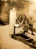
 Drinking fountain and trough at Whitehouse Water trough and fountain at the junction of the A944 and the Keig Road. Sadly, this would appear to...
 Farmtrack on Whitehouse Estate Mature beech trees line the main Whitehouse Estate track. The garden wall of Whitehouse can be seen ...
 All that remains of the glacial meltwater lake? This bog is just about the lowest lying point in the Howe of Alford and may well represent the final...
 Denburn Croft Very little is now left of this former croft, however some foundation stones and stone dykes are vis...
 Whitehouse Crags One of a number of crags of varying sizes, mainly of metamorphic rock and some listed as good traini...
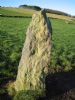 Stone at Tertowie This is listed on CANMORE as a "cattle rubbing stone". It may once have been either a solitary stone...
 A cup marked stone? Could this be a cup marked stone? Found near to the "cattle rubbing stone" near Tertowie.
 Ruins of Tonley House, Tough Bennachie in the distance and the lower slopes of Cairn William in the mid distance. One of the cran...
 Muir of Fowlis View from south east.
 Cairnballoch Ruined steading with Carnaveron to the left and Pressendye as a more distant backdrop to the right. ...
 Newbraes, Cushnie A beautiful photograph showing Bennachie in the background.
Latest Pics